Starling Lawrence called yesterday to tell me that the manuscript was on its way back to me and would arrive this evening or tomorrow morning. He’s made various suggestions for clarification (apparently my account of the war of the Kauravas and Pandavas in ancient India left him scratching his head), but he doesn’t think the revisions will take me long. Good thing, since I’m still supposed to get it back to Norton by February 6.
So I’m looking out the window for the delivery, since drivers who aren’t familiar with our farm tend to drop packages on the porch, where they are fair game for Noodles, the omnivorous beagle.
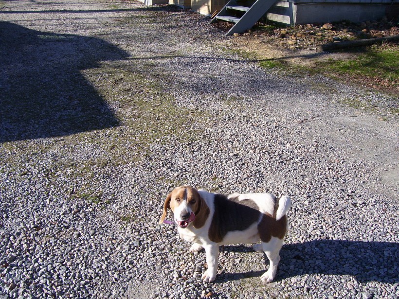
Noodles, licking his lips at the thought of an irreplaceable edited manuscript.
In the meantime I’m frantically working on the maps, which play a very large role in the narrative. There’s a map in almost every chapter, and I’ve only finished about half of them, since the manuscript had to be pretty close to finished form before I could start on them. The total lack of maps in most histories drives me absolutely nuts. History books, particularly popular books (as opposed to textbooks) tend to be weirdly gnostic, as though the surface of the earth and water didn’t really matter all that much. And yet the same mountain passes, harbors, and valleys stand at the center of conflict after conflict, which suggests to me that the landscape is important enough to be included in the story.
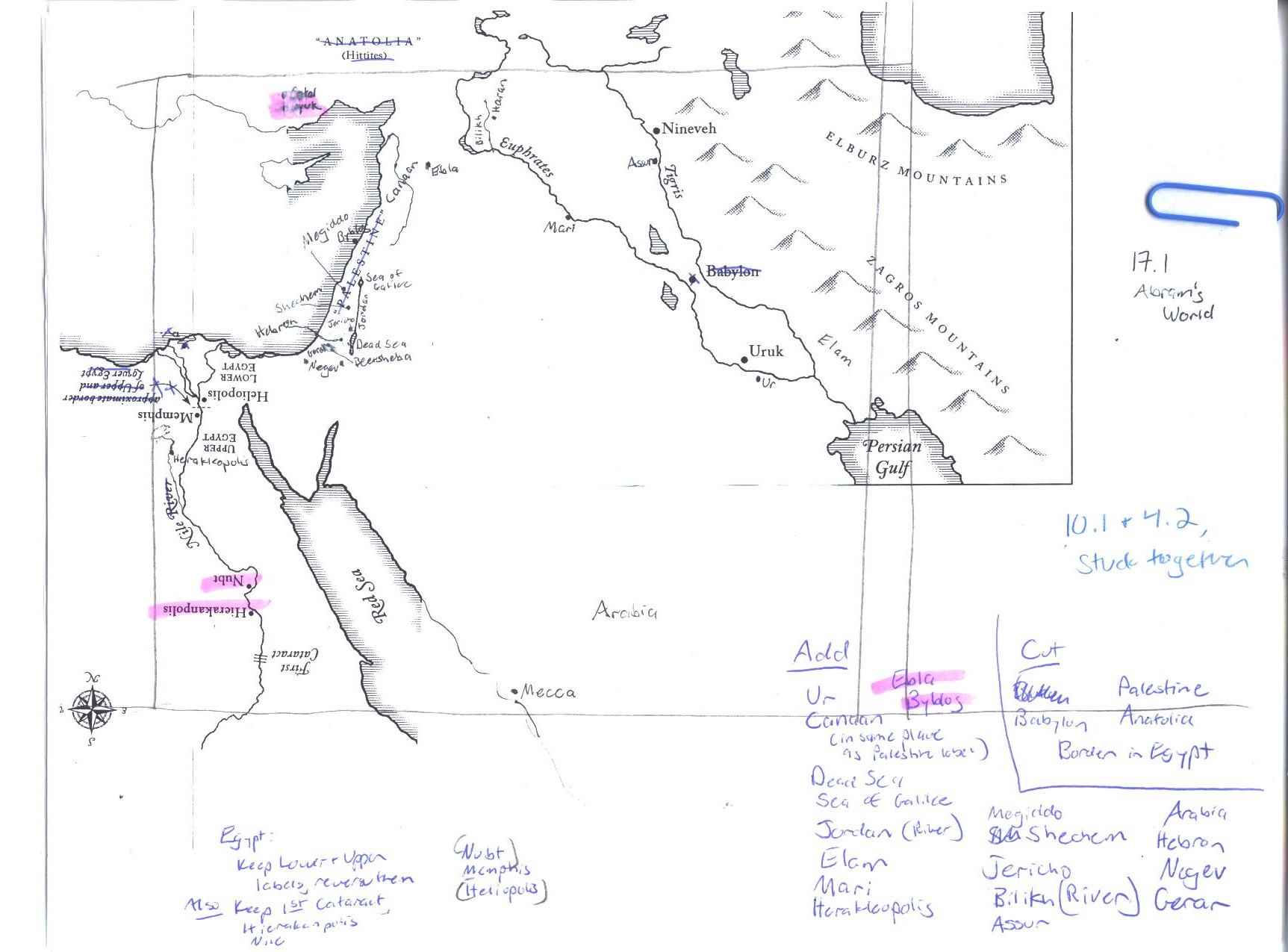
An example: When I was writing Chapter Sixty, about the early republic of Rome, I discovered that one of the earliest treaties between Rome and Carthage (recorded by Polybius) stated that Carthage and Rome would remain friends as long as Roman ships didn’t sail any further west than Fair Promontory. Well, I don’t know where Fair Promontory is. Did any of the forty-two histories of Rome stacked on my floor give me a map? They did not. Did anyone describe where this might be? Nope. I did half a days’ worth of digging before I discovered that Fair Promontory is the modern Cape Bon, and another hour before I found a decent map. I haven’t drawn my own for this chapter yet, but here’s a map I borrowed from the Ancient World Mapping Center (www.unc.edu/awmc):

Fair Promontory is the little finger of land just right of Carthage.
What’s really fascinating is that, two thousand years later, Fair Promontory was still a dividing line between armies. In 1943, the Axis forces in North Africa were forced into surrender when General von Arnim surrendered at Cape Bon–according to the The Guardian (May 13, 1943), “on the extreme tip of the peninsula.” Two days earlier, the Allied forces had “cut off Cape Bon from the mainland and penned its enemy garrison in the mountainous roadless interior of the peninsula,” while Allied naval and air forces blocked any attempts to evacuate Cape Bon by sea–a strategy which E. A. Montague, the Guardian war correspondent, referred to as Germany’s “hope of a Dunkirk” (after the evacuation of Allied troops from occupied France in 1940, in the face of the German advance).
Now you tell ME why no one puts this on a map.
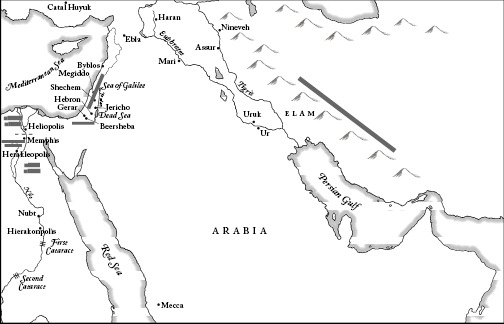
Starling Lawrence has been very understanding of my insistence that the books needs lots of maps, even though they take up plenty of space. So I’ve been working away at drawing maps, and since I’m no artist, I’ve hired the wonderful Sarah Park to take my hand-drawn scribbles and turn them into works of art. Here’s what I gave her to illustrate Chapter 17, “The First Monotheist,” which covers Abram’s wanderings:
This is drawn on a base map which she made for me.
Here’s the finished map for 17 (there are a couple of funny marks on this file because it’s an InDesign file, made for typesetting, not for blogging).
Maps can give you a real glimpse of another way of seeing. It occurred to both of us simultaneously that, since the ancient Egyptians always faced south towards the Nile stream, that it would give a more accurate picture of their world if we oriented their maps south to north, the way they understood the landscape:
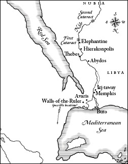
Amazing how much it changes our perspective to shake up that traditional north-south axis. I’d love to know when it became accepted practice to put north at the top of a map. There’s no compelling reason to see the world in this way–and yet how “natural” it seems to us!
Fortunately, the maps don’t have to go into copyediting for another month, so I hope we’ll be able to finish them up on time. Right now I’ll stop blogging and go back to drawing. Our wonderful UPS driver has just arrived without the manuscript, so I’m guessing Norton sent it FedEx. The lookout continues.

Wondering why the crazy lady wants to put his picture on her blog (backing slowly away…)
It strikes me as a bit “old-fashioned” to be exchanging an 11,000 page manuscript by mail. Wouldn’t email be a bit more convenient?
Hope it arrives soon! (And thanks for taking the time to keep this blog.)
–Beth S.
Turning the Egyptian map upside down is great!! I had a college roommate who lived in Brazil for a while, and she and several others from Latin/S.America wore shirts with N&S America reversed — you know, not “backwards,” but from their perspective. 🙂 (In Texas, it was just considered “upside-down.”)
I love the picture of your dog!!!! Not what you were probably wanting comments about, but as a beagle lover, I have to send a “belly rub” to noodles! 🙂
After all these years, I still don’t know how you do it all, Susan. God has given you a gift and I appreciate how you are using it. We’ll be buying your book for our family and home school! And I do love maps, too! GB
BWA HAHAHAHAHAHAAAAAAA!!! Noodles the Omnivorous Beagle!!! Ohmygosh, Susan, that was the BEST!! I loved the picture! ROTFL!!!!!
I’ll never forget the day our first big homeschool book order arrived. The FedEx guy wheeled both boxes in, waited while I signed for it, and then, I guess, his curiosity got the best of him: “What’s IN these boxes, anyway?” LOL. I can only imagine what he would think if an 11,000 page manuscript arrived.
Um, okay, make that 1,100 pages. Come to think of it, the FedEx guy probably WOULD be astounded at a 11,000 page manuscript.
Yes, we homeschool and I’m teaching my children math, why do you ask?
A delivery man is delivering an 11,000 page manuscript. Each box holds 900 pages. How many boxes would it take…
Nevermind.
Maps 🙂 ~ Thank you.
Karen
I’m so thankful you’ll be including maps! Helpful for me and DH will love it. He quite often reads fiction books with a atlas in the other hand.
Omnivorous beagle LOL…we’ve got one of those living next door.
Ah, bless your dear heart for those maps! History needs maps. Thank you for making the effort to make our reading easier!
Love the image of you and Noodles waiting eagerly for the FedEx man, both eager to pounce on that manuscript!
Cordially,
Melora
Ok, I’ll bite. You wrote:
Now you tell ME why no one puts this on a map.
Am I missing something here? (I haven’t really dug into 20th century history yet.) Is there some sort of shenanigans going on here? Or are you just noting the importance of understanding where/what this place was?
Just trying to pick up the cluephone here….
Also – please tell me that you are going to include some maps that will help me wade through Herodotus. Herodotus needs more maps!
Finally – since this blog is about your book, many I ask a question? I am wondering if one of your goals in writing this book was to put together a terrific spine for your own kids to use as they began their own great books/highschool-WTM education. Please tell me that you’ve written the perfect spine that places those great books into context AND includes the non-western history overview that we neglected during logic-stage ancient history. Here’s hoping…..
Janice,
You got me. I really don’t know why there aren’t more maps. It must boil down to time and money (unless someone else has a better idea).
Anyway, there will be plenty of maps, including of Herodotus’s Greece. Have you seen Robin Waterfield’s translation (Oxford World Classics paperback)? He’s got maps both of the ancient world, and of the ancient world as Herodotus knew it–both of which make the Histories clearer.
And yes, I’m hoping that this will be a good (interesting) “spine” for high school students. Although not the “perfect” spine, alas. 🙂 There’s plenty of non-western history, but limited space to refer to the Great Books (although there are chapters on Gilgamesh and the Trojan War, and I make generous use of the ancient Indian epics and the Greek and Roman historians). Here at Peace Hill Press, we’d really like to put out a syllabus to go along with it, but given my tight deadlines for Norton I’m not sure when/if that will happen.
By the way, I got your long email, and will respond as soon as I can–
SWB
Hi Susan! it’s mel. Justin forwarded your blog to me – it makes me miss VA! here’s hoping noodles doesn’t find that manuscript before you.
Hmmm… a syllabus. I was hoping for something along the lines of a full-blown, the-mom-gets-to-check-her-brain-at-the-door curriculum. Tee hee. Of course I don’t mean that, but sometimes I wonder if this task really is too big for me.
If I promise to break your 1100 pages into 36 weeks of manageable 9th grade lessons that will:
-lead the student to a place where he can completely grasp every detail of ancient history
-launch him into a rich study of all the appropriate great books
-provide the incredible discussion starters for the parent that will allow them to lead their child to plumb the depths and view the heights of wisdom
-AND turn them into terrific, inspiring writers…
THEN can I get my hands on it now. 🙂
Have a terrific weekend!
Mel!!! Well, it didn’t show up yesterday, so today I’m back to looking out the window for the FedEx truck–
S.
You know, as I sit here panicking about the five chapters that I have to write for my dissertation, the two words that stood out to me the most in your entry were:
Chapter Sixty.
There are people who write books with sixty-plus chapters.
Chapter Sixty.
Chapter Sixty.
I think those words will be echoing in my mind all day. . .
The six chapters of my dissertation are causing me much more hair-yanking than the eighty-five chapters of this book. I think it has to do with ownership. I’m so aware that the dissertation has got to be “passed,” and so as I write I am continually playing devil’s advocate in my own mind. That’s death to fluent prose. This book, though, is all mine–and there was a tremendous freedom in that knowledge.
SWB
Susan,
I think I stumbled onto the main reason “north is up” by following the globe when I read about the Maori in SOTW 2: the Southern Hemisphere is mostly water. Most of the land needed to support clashing kingdoms and civilizations is in the Northern Hemisphere.
“Just trying to pick up the cluephone here….” Janice, this will immediately become entrenched in my vocabulary!
–Brenda
Thank you! Thank you! Thank you for including maps. That is a huge pet peeve with me and history books. You’re awesome.